|
 |
"The Farallon Light on the Devil's Teeth" |
 |
||||||||||||||||||||||
|
2002 -- San Francisco Maritime Museum |
||||||||||||||||||||||||
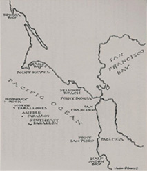
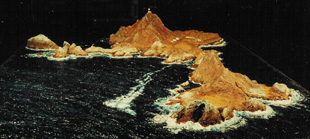
| The Problem: The San Francisco Maritime Museum had acquired a new display space in an historic, 1900 era Fisherman's Wharf warehouse which was undergoing a metamorphosis to become a classy hotel. The plan included an SFMM display space behind a partition of glass across one end of the hotel's lobby, desk and lounge area. The museum's people decided to take this opportunity to display, from their resources, their original first order Fresnel lens. The lens was from the first lighthouse ever constructed to protect the Gold Rush era shipping lanes west of San Francisco from the Farallon Islands. A batch of craggy mountain peaks rising from the Pacific Ocean, the Farallon Islands were referred to as "the Devil's Teeth" in the 1850's. As a contrasting kind of exhibit telling the same story, they decided to go for a diorama of South Farallon Island, the largest of the batch and the location of that lighthouse. The notion was to give visitors some idea of what this place was, and largely still is - a raw and desolate place - but with a predictable, dependable, and fiercely powerful beacon of security for the seafarers 25 miles west of San Francisco. |
|
|
||||||||||||||||||||||
|
|
||||||||||||||||||||||||
|
|
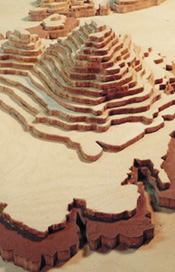
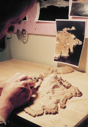 Aerial photos were used to help shape the layers. |
|||||||||||||||||||||||
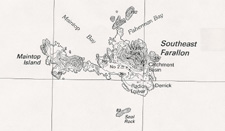
| The Challenge: Determine a scale that would be large enough to include recognizable details of man's presence upon the island, but small enough to present the entire island surrounded by the mighty Pacific Ocean, and still fit on a two foot by three foot base. In addition, while the eastern half of the Island had been documented extensively since the 1860's in photos and etchings, the West End (as it is called) has not. | ||||||||||||||||||||||||
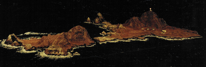
| The series of diorama images below are arranged to represent what you might see from an aircraft making a slow pass around the island. | ||||||||||||||||||||||||
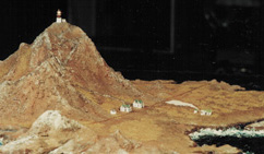
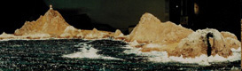 Approaching from the west at about 300 ft. The Great Arch (over 100 ft.high) addorns the West End of Maintop. |
 Crossing Maintop Bay, the craft drops to 200 ft. The lighthouse flares; Arch Rock is at the left. |
|||||||||||||||||||||||
|
The Solution: While we normally make a sight visit to any geographic area we intend to model, the Farallons are 25 miles at sea and a National bird sanctuary with difficult access - both legally and physically. Such a visit was, therefore, not an option. All our understanding came from images (historic and contemporary photos, etchings, etc.) from SFMM, libraries, and the Internet. The determination of the appropriate scale resulted in the smallest scale we had ever worked in, and required us to develop a different approach. We modeled in a scale so small that the little structures were less than half the size of "Monopoly" game houses. As we labored to understand the shape of the West End through interpretation of the USGS topo maps, it began to appear that there was a 100 + foot high - arch at the far west end, but no one had an image. We finally found the corroborating images so the West End could be shaped according to the layers described by the to-PO map, and finally "tuned" according to the dozen or more photos we had selected as illustrating our primary surface flavors. As we developed details for the super-small scale, we happened upon a product for hobby-miniaturists that was intended for modeling a much larger scale lighthouse, but included a little printed circuit board, a small DC bulb and a transformer. We reconfigured the system to use a "AA" battery pack to eliminate the need for a wall plug. We then converted to a smaller - 1/8th inch dia.- DC bulb which we painted and glued on a base collar and a funnel- shaped cap to represent the lighthouse itself. The result is a lighthouse with a 9 second cycle, taking a half-second to ramp-up to its brightest light, which it holds for about a second, then ramps back to 'off'', simulating the sweep of the lighthouse beam. The effect is amazing! Martha's water is once again visably true, and Joanne's earth tones and organic scrubby ground cover read very well. |
||||||||||||||||||||||||
 Turning south and climbing back past 300 ft., the terrace and keeper's houses appear on the left. |
||||||||||||||||||||||||
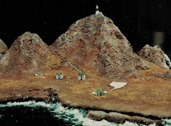 The lighthouse keeper's houses all face south, as do the steam-powered fog horns. |
||||||||||||||||||||||||
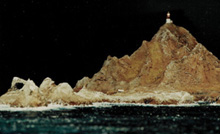
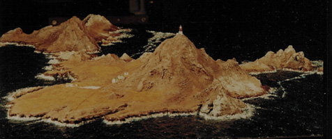 Reaching 450 ft. and turning north, the Great Murre Cave is now visible. Farther around the north side of the island Fisherman's Bay can be seen, and once again, Arch Rock. |
||||||||||||||||||||||||
 Finishing the pass around the north side of the island provides a view of Sugar Loaf Rock and its white frosting of bird droppings. Before its removal in 1969, the light flared exactly every minute so ships at sea could identify that it was the Farallon light and know their exact position. |
||||||||||||||||||||||||
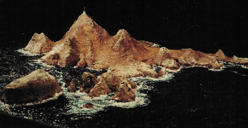
 Turning south across the Jordan Channel that separates the two segments of the island, the light flares a farewell. |
||||||||||||||||||||||||
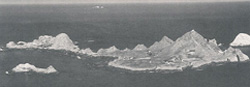
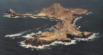 Photo of "the real McCoy"...* |
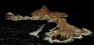 ... compared to the diorama (above). |
|||||||||||||||||||||||
|
*images from "The Farallon Islands - Sentinel
of The Golden Gate" by Peter White
|
||||||||||||||||||||||||